
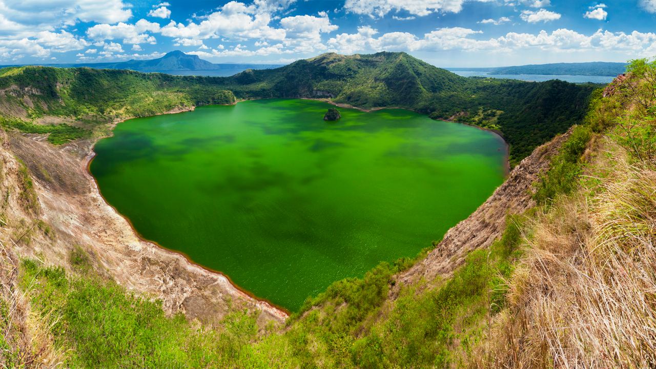
Taal Volcano Tours from Manila and Tagaytay
A lake on an island in a lake in a caldera, 65 km from Manila, and closed to visitors since January 2020. Six listings, and the boats go around rather than across.
Taal is 311 m high and one of the deadliest volcanoes on the planet, which sounds like a contradiction until you look at where it sits. Sixty-five kilometres from a capital of more than thirteen million people, in the middle of a lake that is itself the flooded floor of a much older caldera, with a crater lake on top of it. Thirty-nine eruptions since 1572. And since January 2020 you cannot walk on it, which means every one of the six listings sold here is built around looking at it from somewhere else.
This page is the practical one: how the six days are put together, what the ridge and the boat each give you, the eruptions that made this volcano what it is, and the three things that will decide whether the day works. Why the island is closed and how the rest of the Philippines compares sits on the Philippines page above.
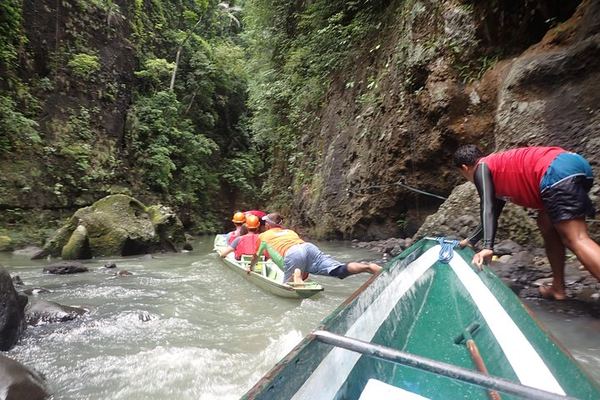
Shooting the Rapids at Pagsanjan and Taal's 38 Recorded Eruptions
Two licensed boatmen row the canoe upstream to the falls, and the way back down is the rapids. Taal has 38 eruptions on record, the last in January 2022.
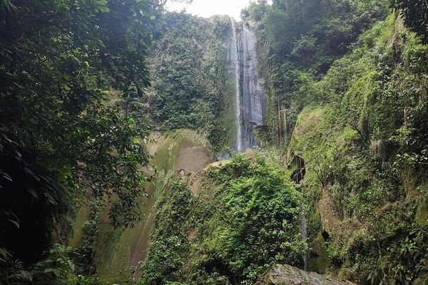
Taal and a Waterfall Behind It: a Rainforest Trail and a Cave Church
The boat round the island comes with a 20 to 30 minute rainforest trail to a waterfall, plus a Catholic church built into a cave that locals keep to themselves.
Taal by Bangka: the Volcano from the Water and the Market at Talisay
Free hotel pick-up across seven Manila districts, a market stop at Talisay, and the crossing to the volcano island on a local outrigger boat.
Taal by Boat (No Crater Trek), a Farm Resort Pool and a Picnic Lunch
No crater trek here, because the alert is still up: the boat stays in front of the volcano, and the afternoon is a countryside pool and a homemade picnic.
Taal from 665 Metres and the Canoe Up to Pagsanjan Falls
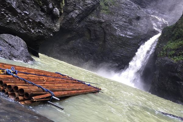
Two local paddlers work the canoe up the rapids to the falls, where you swim into the cave behind the water. Tipping them is expected, not optional.
Taal Town on Foot: Spanish Colonial Streets and the Piña Embroidery Market
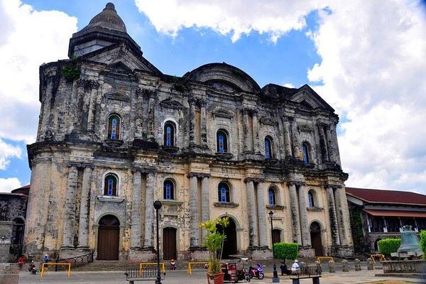
The colonial town is walked rather than driven, 20 to 30 minutes per stop, and the market sells the piña and jusi embroidery Taal is known for.
Ratings collected by Viator and Tripadvisor
The geography, which is genuinely confusing
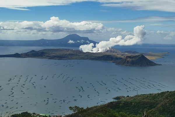
People arrive at the Tagaytay ridge, look down, and cannot work out what they are looking at. Here is the nesting, from the outside in. The bowl you are standing on the edge of is a caldera roughly 25 km across, left by prehistoric eruptions far larger than anything in the historical record. That bowl has filled with fresh water and is now called Lake Taal. In the middle of the lake is Volcano Island, about five kilometres wide, which is the active vent. On the island is a crater, and in that crater there is another lake. On a good day you can see a small islet in that inner lake, which is the point at which most visitors give up trying to explain it to whoever is on the other end of the phone.
Two numbers make the scale legible. The ridge you are standing on is 665 m above sea level, and the volcano across the water is 311 m. You are looking down on an active volcano from more than twice its height, which is why the photographs from here work so well and why the viewpoints have never had to close.
What the six days consist of
All six start with a hotel pickup in Manila and an air-conditioned vehicle, and all six put you on the Tagaytay ridge at some point. What separates them is what gets bolted on: a boat, a heritage town, a waterfall, or a full second destination in Laguna province. The shortest is six hours and the longest ten.
| The day | Price | Hours | Rating | What you get beyond the ridge |
|---|---|---|---|---|
| Countryside and volcano | 99 EUR | 6 | 4.8 | Talisay market and a boat around the island |
| Private ridge view with Pagsanjan | 110 EUR | Full day | 4.7 | Picnic Grove viewpoint, then the Laguna rapids |
| Volcano and a hidden waterfall | 119 EUR | 8 | 4.9 | Boat, a rainforest waterfall walk, a cave church |
| Ridge, boat, resort and lunch | 123 EUR | Full day | 4.7 | Boat plus a lakeside resort and picnic lunch |
| Taal heritage town | 159 EUR | Full day | 4.8 | Walking tour of the Spanish colonial town |
| Pagsanjan Falls and Taal | 190 EUR | Full day | 4.9 | Dugout canoe up the Pagsanjan rapids |
Two observations from reading the itineraries rather than the titles. First, the review counts behind those ratings run from 25 to 131, an order of magnitude thinner than the mature volcano destinations, so a 4.9 here carries a lot less information than a 4.9 in Sicily. Second, the two Pagsanjan combinations put a long drive across Laguna province on top of a long drive to Tagaytay. They are the most expensive listings and the ones with the most windscreen in them.
The heritage town at 159 EUR is the better pairing and almost nobody frames it correctly. The town of Taal is where it is because the volcano destroyed the previous one: the great eruption of 1754 wiped out the lakeside settlements and the survivors rebuilt on higher ground to the south. The colonial houses and the basilica you walk around are the second attempt. That is a volcano tour, even though it is sold as architecture.
The ridge and the boat
The ridge is the reliable half of the day. Tagaytay runs along the caldera's northern rim, about 12 km from the crater, and the viewpoints there, Picnic Grove among them, are the classic vantage. It is roughly six degrees cooler than Manila, which is why the city built its weekend houses up here, and the view works whether or not the volcano is doing anything.
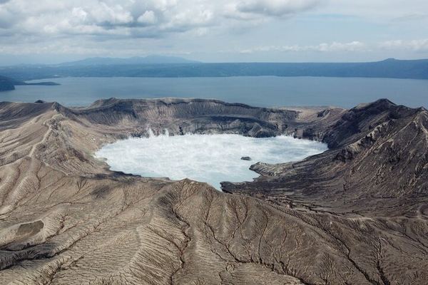
The boat is the variable half. Three listings include one, and it is a bangka, the outrigger canoe used all over the Philippines, usually from the Talisay shore on the northern side of the lake. What it does now is circle the island close in without landing: you see the flanks, the ash-grey ground where the 2020 eruption stripped the vegetation, the fishing communities along the shore, and the steam coming off the crater when it is venting. What it does not do is put you on the volcano, and no operator can lawfully offer that.
If you have read a review, a blog or a guidebook describing a pony ride from the beach up to the crater rim, it was written before January 2020. Nothing about that product exists any more, and its continued presence in search results is the biggest single source of confusion about this destination.
One listing at 119 EUR adds a waterfall in the rainforest above Laurel and a cave church that its own description says is known mostly to locals. Its text describes the waterfall walk as twenty to thirty minutes and admits it can be a bit challenging, which is more honest than the physical-fitness line every listing carries, and it is the only Taal product here with anything resembling a hike in it.
Four and a half centuries of a very small volcano
Thirty-nine eruptions since 1572, and the four that changed what stands around the lake.
The origins
1754
The lakeside towns are destroyed
The largest eruption in the historical record runs for months and buries the settlements around the lake. Taal, Lipa, Tanauan and Sala are rebuilt elsewhere afterwards, which is why the colonial town one listing visits stands where it does.
1911
The island is destroyed
One of the deadliest eruptions in Philippine history reshapes the island and wipes out the settlements on it and along the near shore. The crater lake visitors photograph today dates from this reorganisation of the summit.
The growth
1965
The eruption that named a phenomenon
A blast from the south-western flank sends ground-hugging surges of ash and steam racing across the water. Studying it is where volcanology borrowed the term base surge from nuclear weapons testing, and it is why the lake shore is treated as inside the hazard zone.
Today
2020
12 January
An eruption column rises around 14 km, ash reaches Manila, 39 people are killed and roughly 376,000 are displaced. The island is evacuated and never reopened to visitors. Every product sold here today is a consequence of this date.
2024-2026
Small eruptions, most months
Since April 2024 Taal has produced a long run of minor phreatomagmatic events, brief bursts of ash and steam from the crater lake lasting one to five minutes. In July 2026 alone there were at least four, one of which threw jets around 2.8 km above the crater rim.
Three things that will actually affect your day
The departure time. Tagaytay is about 60 km from central Manila and takes an hour and a half to two hours when the road behaves. It frequently does not. Listings that specify their pickup zones cover Makati, Taguig, Ermita, Malate, Las Piñas, Muntinlupa and Pasay and charge extra outside them. Ask what time the vehicle collects you before you compare anything else, because a six-hour tour that starts at nine is a very different day from one that starts at six.
Vog, when the wind is wrong. Taal emits sulphur dioxide continuously and the amount swings enormously: readings of 129 tonnes a day and 741 tonnes a day were recorded two days apart in July 2026. When output is high and the wind sets north, the haze reaches the ridge and residents of Tagaytay report the smell of sulphur. In 2022 a sustained episode damaged vegetation around the caldera. It is not dangerous at the viewpoints, but it can flatten the view you paid for, and no forecast will tell you in advance.
Lunch, which is almost never included. Read the exclusions. On most of these listings food and drink are extra, and the ones that do include a meal say so in the title. Tagaytay is full of restaurants with a view of the volcano and prices to match; the market stop at Talisay that one listing includes is the cheaper alternative and the more interesting half hour.
Questions people actually ask
Can I go on the volcano island?
No. Volcano Island has been declared a permanent danger zone, settlement on it is banned and the main crater is off limits. The boats that are sold today circle the island without landing. This is not a temporary closure tied to the current alert level, and it has been the position since the January 2020 eruption.
Is the boat trip worth paying for?
If you want to see the island close up and the state of the ground after 2020, yes, and it puts you on the lake, which is a different experience from looking down at it. If what you want is the postcard, the ridge gives you that and the boat adds two to three hours to the day. Three of the six listings include one and the cheapest of those is 99 EUR.
How long from Manila to Tagaytay?
An hour and a half to two hours for about 60 km, and longer at almost any predictable time. Traffic is the real variable in this destination. Every listing here includes hotel pickup, and an early start is the single most valuable thing to negotiate.
Is Taal erupting at the moment?
It has been producing minor phreatomagmatic events for a long stretch, including several in July 2026, which are short bursts of ash and steam from the crater lake rather than anything that closes the region. Check the current alert level and any advisory with the Philippine institute of volcanology before you travel: activity has been continuing and the picture can change within a week. The ban on the island applies regardless.
What is the best viewpoint?
The ridge road through Tagaytay has several, and Picnic Grove at around 665 m is the one most listings use. They all look at the same thing from slightly different angles. What matters more than which one is what time you get there: the haze over the lake builds through the day, and the light is better and the air clearer in the morning.
Is it suitable for children or older travellers?
Yes, more than almost any other volcano in this catalogue. There is no climbing involved. The listings state that they suit all fitness levels, with the usual cautions about the boat for pregnant travellers and anyone with a back or heart condition. The exception is the one listing that includes a rainforest waterfall walk, which its own description admits is a bit challenging for some.
What should I bring?
Sun protection, because the ridge is exposed and the reflection off the lake is strong. A light layer, because Tagaytay is several degrees cooler than Manila and windy on the rim. Cash for lunch and for the market stop. And low expectations about the drive, which is a significant part of what you are buying.
Data verified on. Eruption history, access restrictions and 2026 activity from Philippine institute of volcanology bulletins and the published record. Prices, durations and itineraries from the products on this site.