
Volcano Travel · Tour
Etna North Volcanological Trek: Inside an Intact Cone, Craters Back to 1614
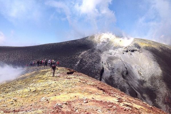
An alternative to the summit craters, for people who would rather walk among craters, ground fractures and lava flows than queue for the top. The 4x4 climbs from 1,800 to 2,800 metres, eight kilometres of road, with the volcanological guide starting the explanation on board rather than at the end of it. The route takes in the Rift, the fracture on the north side of Etna. It goes inside the chimney of a volcanic cone that survived intact, which is what the protective helmets are for: standing in a feed duct means standing where the molten magmatic mass once boiled. Then the mouths that produced the lava flows, the rims of large craters, and descents down slopes of volcanic ash, between cones left by lateral eruptions too numerous to count. The walking is around 7 km, and good fitness is needed for it. The craters along the way are dated: 2002, 1911, 1923, 1874, 1879, 1809, 1646, 1614, 1624. Between the first and the last of those lies four centuries of the same mountain doing the same thing in different places. The route was once used by researchers, and the guides are certified volcanologists. The meeting point is the Chiosco Bar Mareneve, not the Chiosco Bar Etna Nord.
What's included
- Entry/Admission to Mount Etna
- Licensed Volcanological Guide
- Trekking poles, trekking shoes, helmets, warm jacket, extra socks, extra backpack
- Insurance in case of accidents
Itinerary
The map could not be loaded. Please try again in a moment.
Etna nord-Piano Provenzana, Via Provenzana, Linguaglossa
The meeting point is in the car park by the chairlift that runs at Etna Nord in winter. Look for the second of the four buildings there. It is the "Chiosco Bar Mareneve", not the "Chiosco Bar Etna Nord".
Piano Provenzana
Piano Provenzana is the northern tourist station of Etna, and you reach it with your own car. It is less crowded than the southern slope, and the access road runs where dense forest meets the bare lava of recent eruptions. At 1,800 m there are small souvenir shops, cafés, restrooms, and the departure area for the authorised 4x4 vehicles. Parking is paid, in the blue-striped spaces. Beyond this point you can only continue with licensed guides, on vehicles approved by the park and the municipality. In winter the same place is a ski station. This ground sits inside the lava field of the 27 October 2002 eruption, which destroyed the tourist facilities that stood here: restaurants, hotels, ski lifts and trails. Excursions from here climb from 1,800 m to about 2,860 m, at the Etna Nord Volcanological Observatory.
Costo extra
Itinerario Crateri Sommitali
The tour starts on the panoramic road up the north slope, which only authorised 4x4 vehicles may use. The guide meets you at Piano Provenzana, 1,800 m, for a short briefing. The drive crosses the woods and the wide lava fields of the 27 October 2002 eruption, where the ruins of the old tourist station still come through the surface, including the half-buried roof of a hotel. The guide covers the volcano's history on the way and takes questions. The road passes craters more than 40 m deep, eruptive fractures and wide summit lava flows. Pioneer plants have taken hold on the new rock, and INGV monitoring stations stand out on ground where nothing else does. The route ends at Piano delle Concazze, 2,860 m, next to the Etna Nord Volcanological Observatory. On a clear day the view runs from Catania to Syracuse, across the Nebrodi, the Peloritani and the Madonie, out to the Aeolian Islands and over to Calabria, with the summit craters steaming above.
Mount Etna
The wild north flank of Etna, on a route that used to be for researchers and is now walked with certified volcanologists. From Piano Provenzana, 1,800 m, reached by paved road, the authorised 4x4 vehicles take the panoramic north road, crossing forest and the lava fields of the 27 October 2002 eruption, past the ruins of the old tourist station and the half-buried hotel roof. They climb to about 3,000 m, the highest point allowed when the summit is closed, with the active craters fuming overhead. The hike is around 7 km, so good fitness matters. It crosses a plateau of fresh lava and ash, taking in craters from 2002, 1911, 1923, 1874, 1879, 1809, 1646, 1614 and 1624, the north-flank fault, ancient lava tubes and pioneer plants. The view reaches the Aeolian Islands, the Nebrodi, the Peloritani, the Madonie, Calabria, and the east coast of Sicily from Catania to Syracuse. The descent goes down sandy channels and through forest, back to Piano Provenzana.
Piano Provenzana
Back at Piano Provenzana at the end of the day, with the pine forest on one side and the lava field on the other. There are souvenir shops, cafés and bars for a coffee or something to eat, and places to refill a water bottle. The blue-lined parking areas take cars and camper vans. The October 2002 eruption is the reason this station looks the way it does: it destroyed what stood here and left the ground you have just spent the day walking on. Of the Etna stations this is the quiet one, and after several hours on the north flank the difference from the southern side is easier to judge.
Etna nord-Piano Provenzana, Via Provenzana, Linguaglossa
Not included
- windbreaker
- Parking ticket (€5 for the entire day on weekdays and €8 on Sundays and public holidays.)
- (50€ per person to be paid on the spot) for vehicles 4x4 from 1800m. at 2800m. from 2800m. at 2500m.
- Transport service from your accommodation
Good to know
- Service animals allowed
- Infants are required to sit on an adult’s lap
- Not recommended for travelers with spinal injuries
- Not recommended for pregnant travelers
Show 13 moreShow less
- Not recommended for travelers with poor cardiovascular health
- Travelers should have at least a moderate level of physical fitness
- This type of itinerary, in relation to the type, is suited to people in good physical health, not suffering from particular disease (it is strongly discouraged to those who suffer from cardio-vascular problems, breathing problems or hypertension).
- The route consists of the ascent and the walking along the crater edges, this may cause dizziness to susceptible individuals.
- The excursion requires a good preparation on a physical level. Because of it results to be a high height path, it would be easy to experience symptoms of fatigue.
- Trekking is not recommended for those who does not do physical activity regularly.
- For the success of the excursion and for its correct carrying out, it’s good to know perfectly your health conditions and, if necessary, let the Guides know about them, in order to reduce the occurrence of any problem and to avoid any risks.
- It is required also to be careful, since it is volcanic soil, often inconsistent and unstable.
- The route is also suited for children over 6 years old.
- We recommend not to use contact lens, because of the exhaled volcanic gases and of ash. This last one could easily cause problems, if pushed.
- Up to 15 travelers per booking.
- Mobile or paper ticket accepted
- Guiding available in: en, it, fr.
Reviews
Loading reviews…
Keep exploring
More experiences in Mount Etna
-
 Selling fast
Etna by Helicopter, 30 Minutes from Fiumefreddo: Eight Landmarks from Above
5.0 (87) 5.0 stars out of 5, 87 reviewsHalf an hour above the summit craters, the Valle del Bove and Piano Provenzana, from the private heliport at Fiumefreddo. Maximum weight per passenger: 105 kg.
€ 350.00 -
 Free cancellation
Etna Central Crater at 3,345 m, Worked from Both the South and North Sides
4.6 (65) 4.6 stars out of 5, 65 reviewsAn itinerary that works both flanks of the volcano rather than committing to one, with the Central Crater at 3,345 m as the target. Meets at Linguaglossa.
€ 45.00 -
 Free cancellation
Etna Family Tour: Two Households Max, and an Etna Ranger Badge at the End
5.0 (385) 5.0 stars out of 5, 385 reviewsTwo households per departure, the walk pitched to the children's ages, and a kit each: backpack, book, pen, and an Etna Ranger badge handed over at the end.
€ 85.00
Ratings collected by Viator and Tripadvisor